| My Experience | |
|---|---|
| Number of Visits | 1 |
| Length of Stay | 6 Days |
| My Favorite Spots | Sand Beach Great Head Trail Cadillac Mountain Summit Bass Harbor Lighthouse Sea Anemone Cave |
| Expenditures | Hotel: Not Recorded Flight: Not Recorded Rental Car: Not Recorded Food: Not Recorded |
| Miles Hiked | ~15 |
| # of Photos Taken | Not Recorded |
The Trip Overall
Acadia National Park is located on the South coast of Maine. It is touted as being the first National Park East of the Mississippi. I was intrigued to visit Acadia for several reasons. First, Acadia has one of the most beautiful displays of Fall color in the country. Secondly, despite living within a 3-hour drive of the Atlantic and a 45 minute drive of Chesapeake Bay, I rarely get a chance to take seascape photos. Much of Acadia’s beautiful scenery lies along the rocky coast. Finally, I wanted to photograph the Bass Harbor Head Lighthouse; one of the most iconic photo locations in the U.S.
I spent six days in Acadia around the time of the 2013 U.S. federal government shutdown. I had planned this trip months before anyone knew that would happen. Luckily, the park is relatively small and I was able to park at roadblocks near the park and then hike in. About 2/3 of the way through the trip, the park reopened and I was able to explore the interior.
The Map
As you can see in the map below, many of the photo locations I was most interested in fell along the Eastern shore. Not surprisingly, that is where I spent the majority of my time. Cadillac Mountain, Jordan Pond, Bass Harbor Head Lighthouse, and the network of Carriage Trails round out the top spots.
[googlemaps https://www.google.com/maps/ms?msa=0&msid=215447723233123953430.0004d5c59092d9dd7a016&ie=UTF8&t=h&ll=44.326795,-68.315735&spn=0.245601,0.668793&z=11&output=embed&w=1200&h=600]
Click on the camera icons to see a photo, a location name, and coordinates for the closest parking area. I also show park entrances, visitor centers, the hotel(s) where I stayed, hiking trails, and airports.
Visitor Statistics
As with most of the parks, traffic in Acadia peaks in July and August. Cruise ships dock in Bar Harbor almost every day through October though and many of those people find their way into the park during the day. Fall color tends to peak in mid-October and that tends to draw a crowd as well.
This graph shows the average number of visitors each month. Hover over the line to see values for each month. NOTE: Even though the X-axis reads “2000,” these are monthly averages from the most recent 5-year period. The “2000” should be ignored.
The Climate
This graph shows average temperature and precipitation by month. Hover over the line to see values for each month. You can select different variables and parks in the panel on the left. NOTE: Even though the X-axis reads “2000,” these are monthly averages of NOAA weather data dating as far back as the early 1900’s. The “2000” should be ignored.
Logistics
| NPS Survey Findings(1) | |
|---|---|
| % Visiting for First Time | 50% |
| % Staying More than 24 Hours | 63% |
| Average Length of Stay | 70 Hours |
| Top 5 Sites Visited | Cadillac Mountain Summit (75%) Jordan Pond House (67%) Sand Beach (63%) Thunder Hole (62%) Seawall Area (36%) |
| Average Expenditures | -Not Reported- |
| (1) Visitor Survey Project Report Acadia National Park 2009 | |
Lodging
I stayed at the Quality Inn on the outskirts of Bar Harbor. It is a no-frills hotel. The room was nice and they had a nice breakfast (a step up from continental) that was included in the cost of the room. It’s not an easy walk to downtown Bar Harbor, but it’s an easy drive.There are several large lots near downtown. Still, if you’re planning on bar hopping, you might want to find a place a bit closer. The hotel is also on the far side of town from many of the places you’ll want to go in Acadia. You’ll have to drive through town to get to there. This wasn’t a big issue for me because I often left before sunrise or came back after sunset, but mid-day, when there’s a cruise ship in port, there are pedestrians everywhere and driving is slow-going.
Food
I stopped at the Hannaford Grocery Store a couple times on this trip. It’s a short drive from the hotel where I stayed. It was convenient and most of my meals came from things that I purchased there. I only ate the hotel-provided breakfast once because I was usually out taking photos during breakfast hours. I only ate one restaurant meal on this trip. Before I went, I told myself that I would have a lobster roll in Maine. I ended up getting mine at the Side Street Cafe. It was my first lobster roll so I’m not sure how they should taste, but I wasn’t that impressed with the one I had.
My Experience
I had a very unusual time in Acadia, so my experiences may not serve as much of a guide for your trip. I visited the park during October 2013, during the last week of the government shutdown. The park was officially closed for three of the five days I was there. Luckily, the Park Service was loosely enforcing the closure, meaning I could enter the park but only on foot.
Day 1
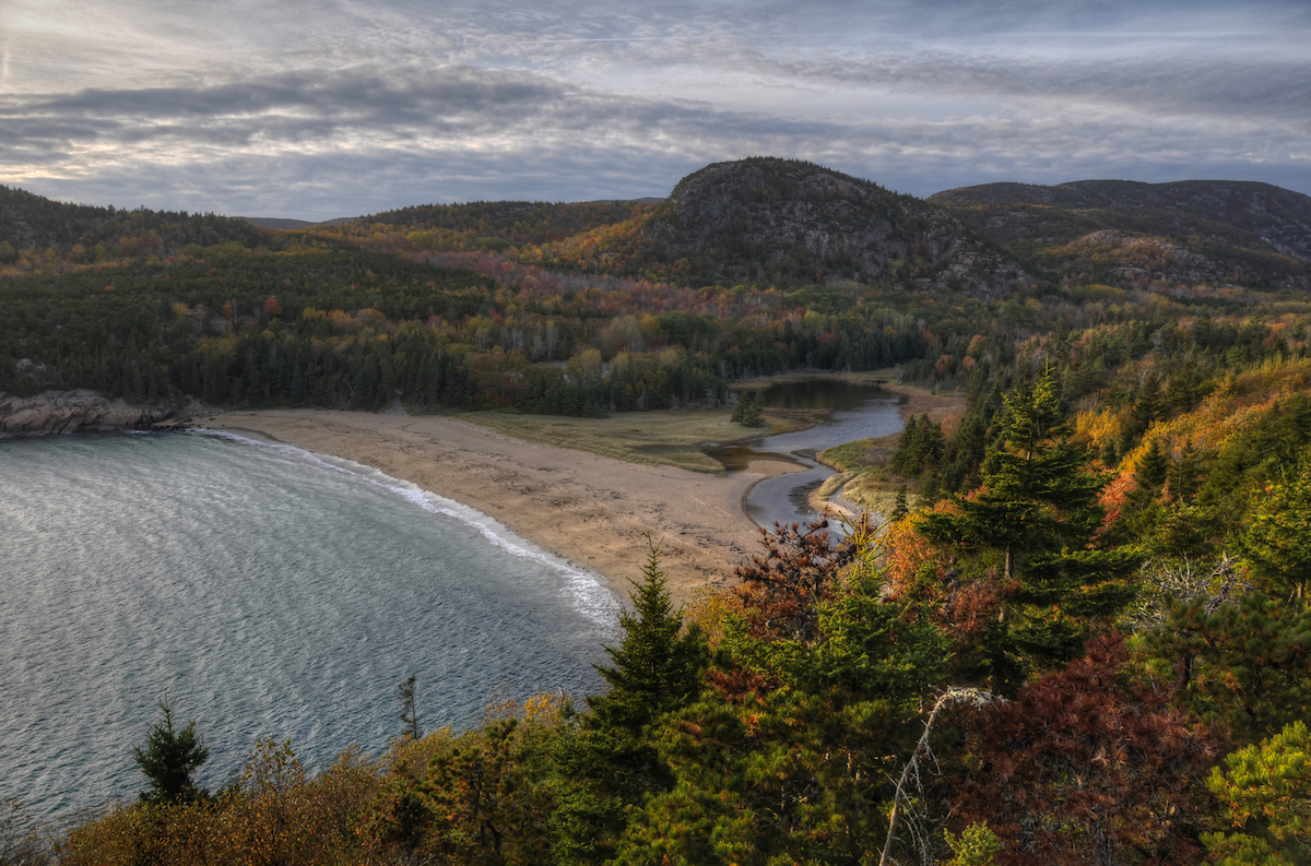
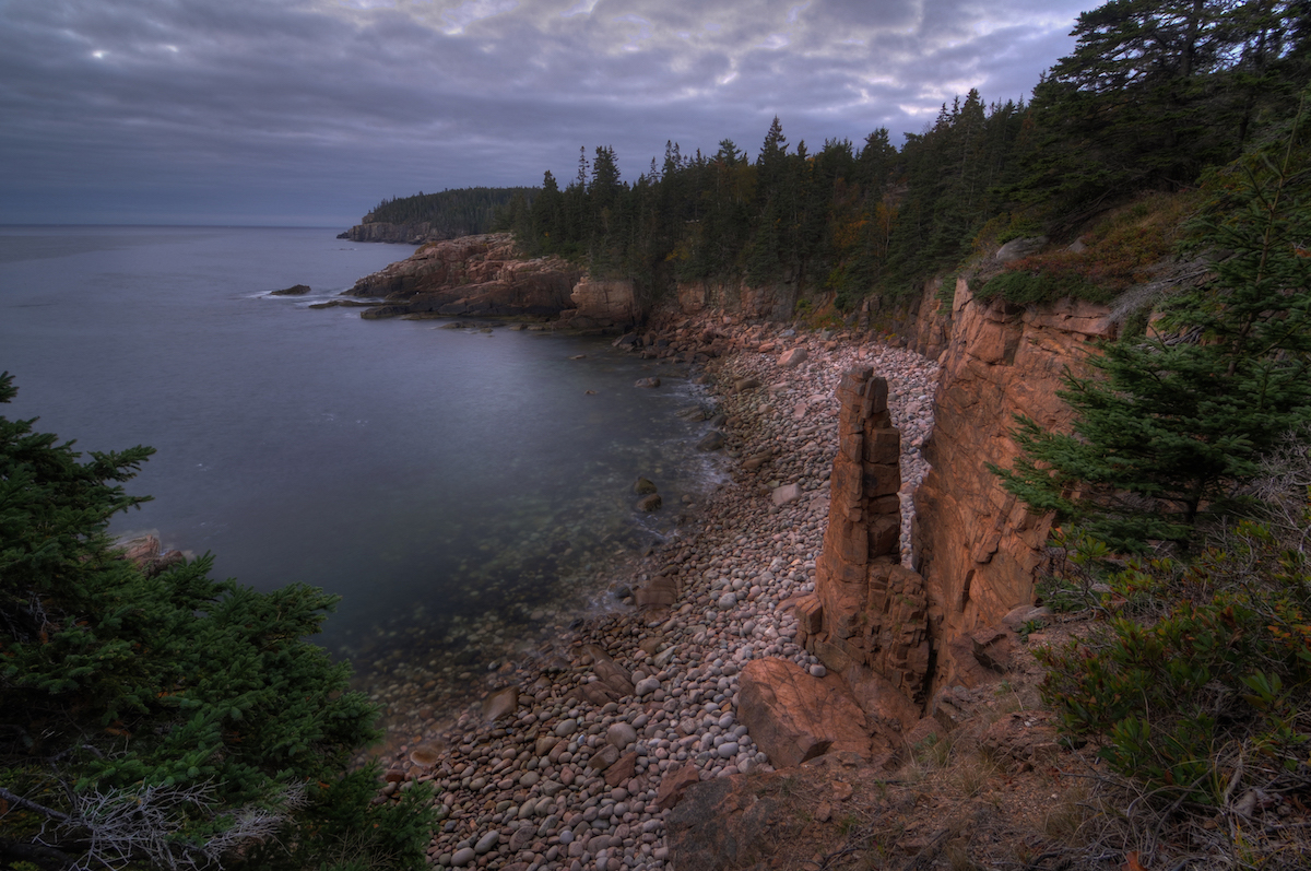
The trip to Acadia was one of the easiest I’ve had to any National Park so far. It was a non-stop flight from Regan National Airport in DC to Bangor, ME. From there, I rented a car and made the 1 hr. 15 min. drive to Bar Harbor. I checked into the Quality Inn, got lunch at the Side Street Cafe, and bought groceries at the Hannaford grocery store. I then started driving the boundary of the park trying to find a place where I could park and walk in (I’d heard about the no-car-during-the-shutdown rule on Twitter). I found a perfect spot where Otter Cliff Rd. meets the Park Loop Rd. From there, I started walking North on Park Loop Rd. scoping out sunrise locations. I walked by Monument Cove, Thunder Hole, and Sand Beach. For sunset, I found myself on the Great Head Trail overlooking Sand Beach and the Beehive. Through sunset and twilight, I worked my way back South along the Park Loop Rd. back toward my car.
Day 2
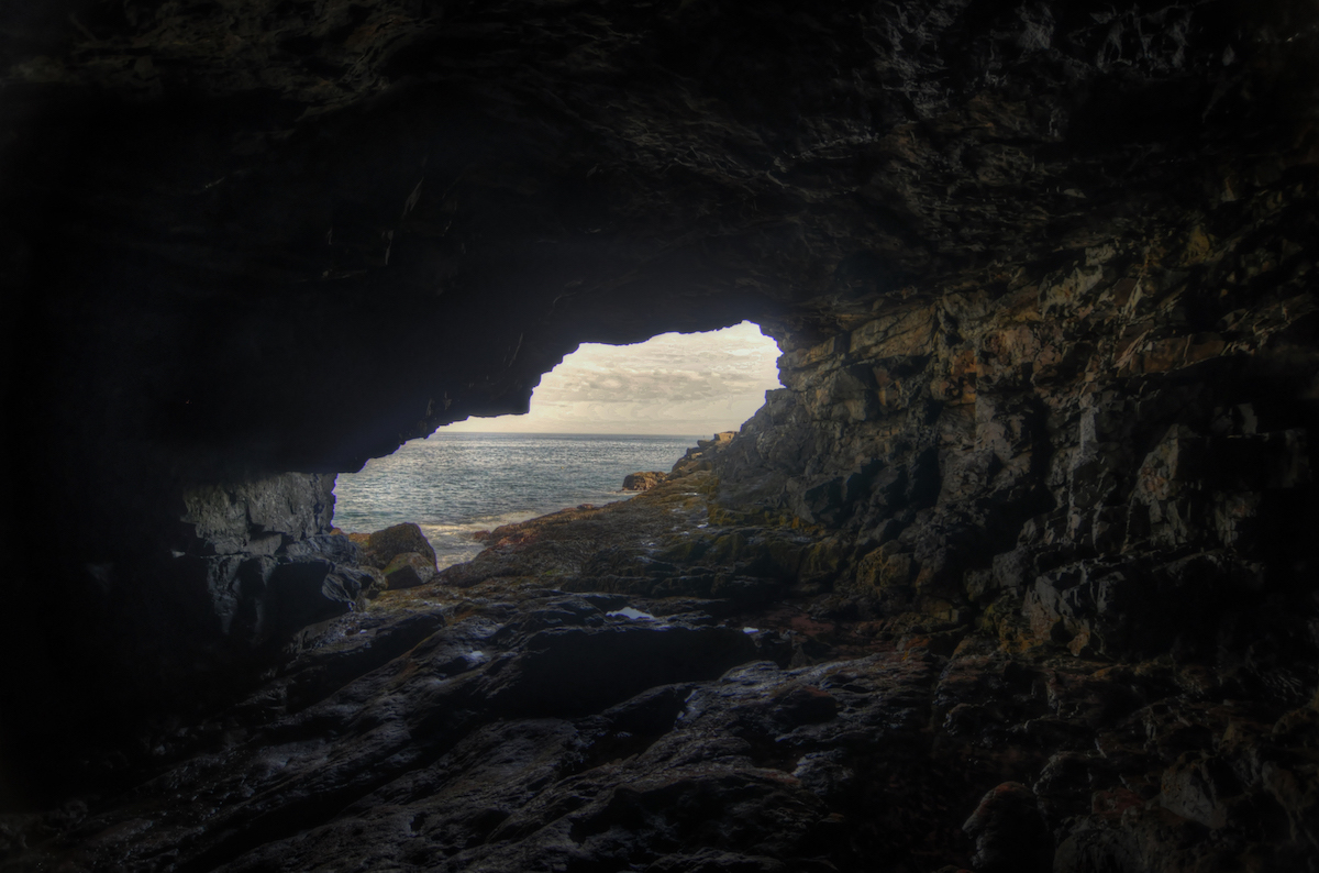
For sunrise on Day 2, I parked in the same spot and walked the short distance to Monument Cove. I arrived there about 45 minutes prior to sunrise and it was still dark, so I ventured out onto the coast and tried to capture some long-exposure shots of the waves crashing on the rocks. At sunrise I was back at Monument Cove. I then walked North again; back to Sand Beach taking photos along the way. At around 9:00 a.m., I drove back to the hotel and ate some breakfast. I ended up watching the latest news about the government shutdown and didn’t venture back out until the afternoon. I went to Schooner Head to catch low tide. I timed it that way so that I could climb down to the Sea Anemone Cave. From there, I drove across the island to the Bass Harbor Head Lighthouse. I arrived there three hours before sunset and hung out along the shore until the sun went down. Three hours was definitely too long to spend there, but I was glad to have staked out a spot. It was very crowded at sunset and there is limited space. I ended up taking slight variations of the same composition because there wasn’t much room for me to move without getting in someone’s way. After the sun went down, I called it a night.
Day 3
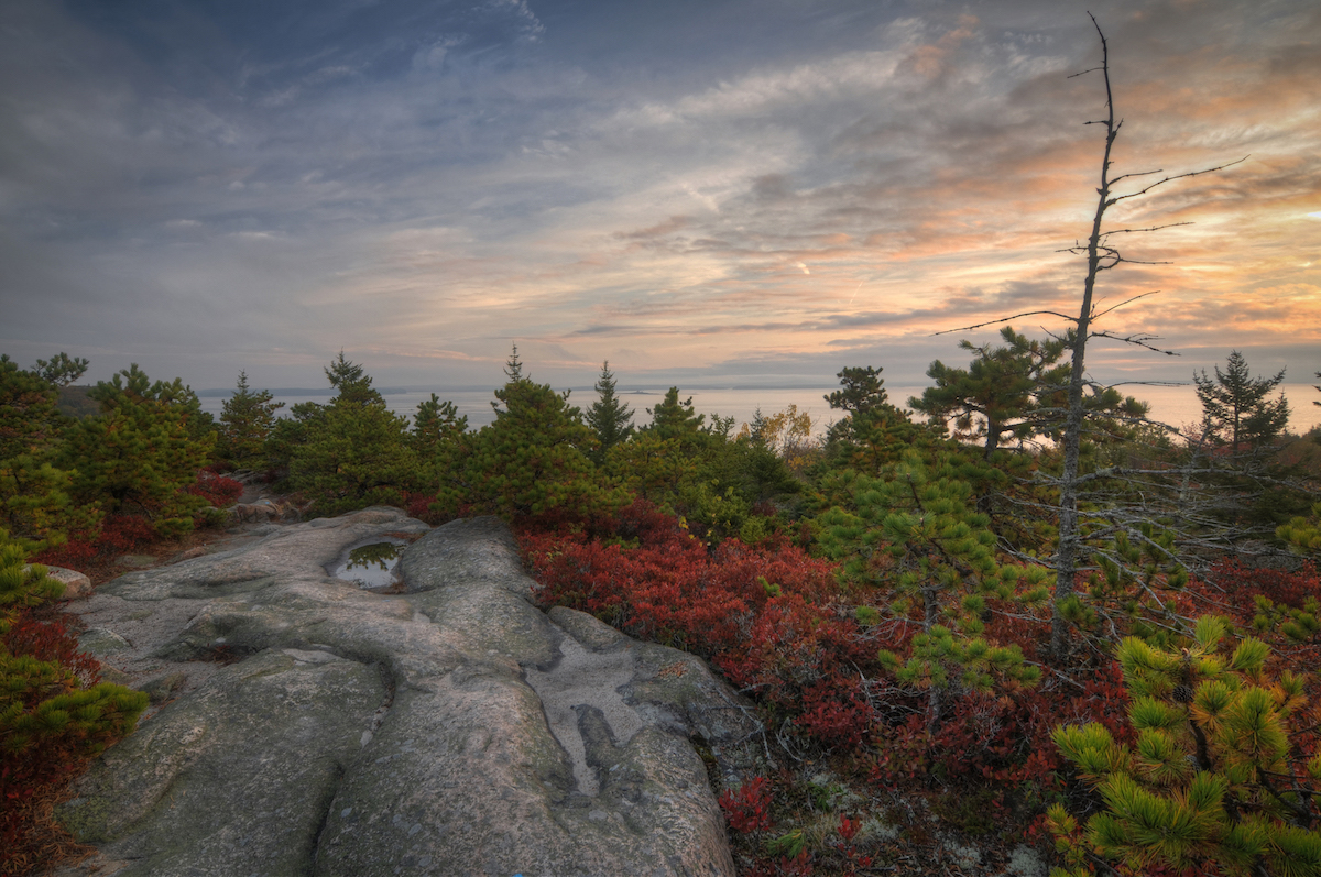
The next morning I hiked the Great Head Trail. I started from the Schooner Head parking area and walked clockwise around the head. It was still twilight when I took pictures along the Eastern shore and then I rushed to the Sand Beach overlook to catch the first rays of light there. I was disappointed with the light so I continued to walk the trail back toward the parking area and found some beautiful, colorful shrubbery. I spent the rest of sunrise there, along the trail. Next, I went to climb the Beehive. I made it about 1/3 of the way up the Precipice Trail before getting frightened and heading back down. The trail is very narrow and at points you have to hold onto or climb rungs that have been drilled into the rocks. Luckily, the park was still closed and there weren’t many people in the park. It would be hard to climb back down if there were people heading up. Once I made it down, I took another trail to The Bowl; a small lake. I took a number of pictures of the wooden walkways around the lake and Fall leaves. By the time I made it back to my car, it started to rain heavily and I spent much of the rest of the day at the hotel processing photos and watching the news. Late that evening is when a deal was worked out and the shutdown ended.
[youtube=https://youtu.be/AkhZaOR6hQ8]
Day 4

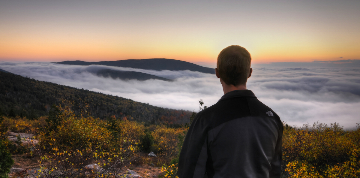
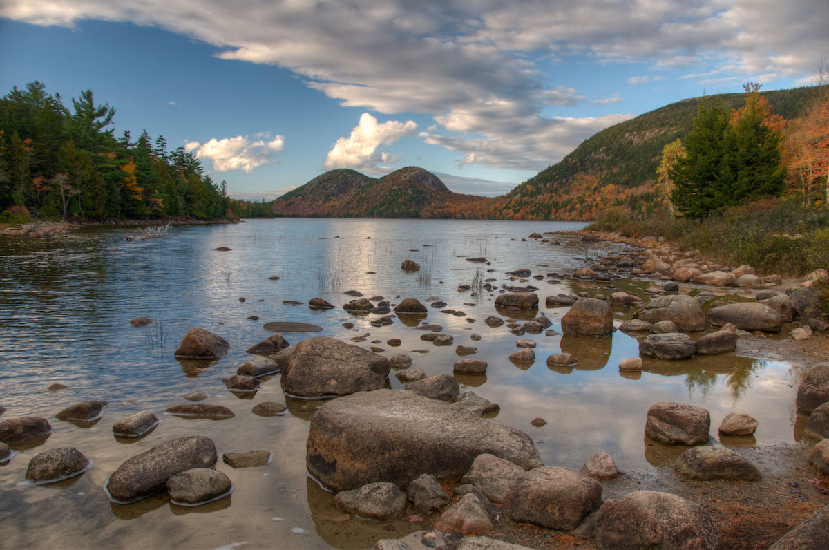
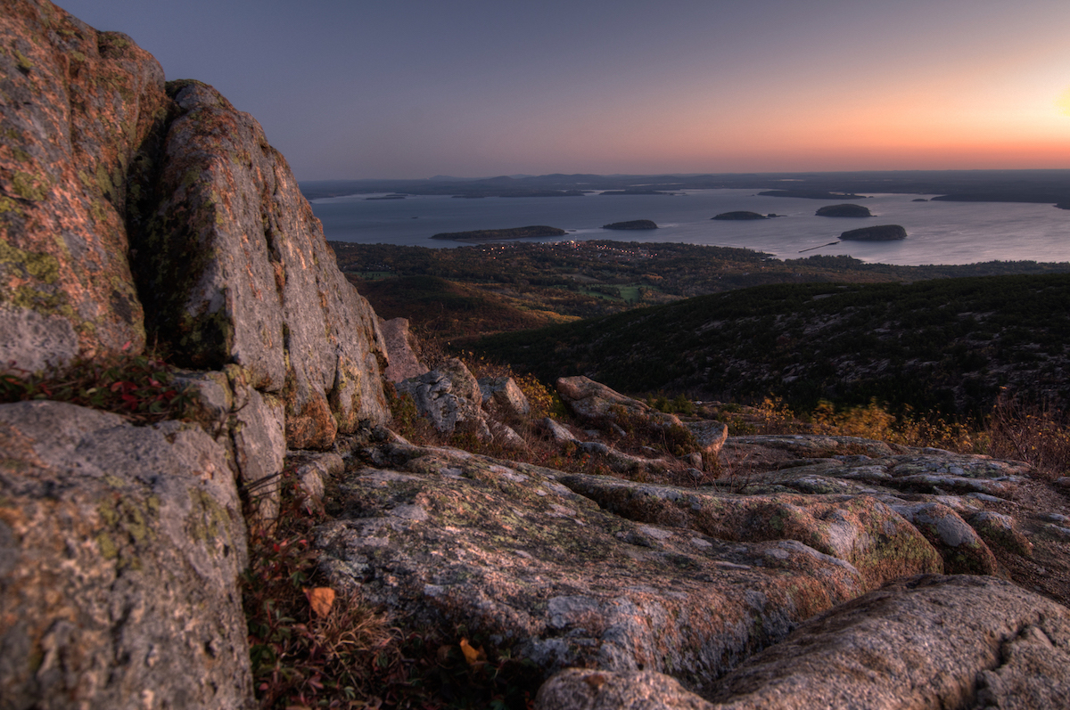
Though the shutdown ended the previous night, the barricades hadn’t been taken down as of early morning on Day 4. Once again, I parked at Otter Cliff Rd. and Park Look Rd. and walked out to the coast. It was cloudy so there wasn’t much of a sunrise that morning, but I tried my hand at some coastline shots. Once I saw the Park Rangers driving the Park Loop Rd., I jumped in my car and started to drive it myself. I drove to Jordan Pond. It was foggy there so scenic shots of the lake and The Bubbles was out. I hiked the wooden pathway along the shore of the lake and took Fall foliage shots. I then drove to the summit of Cadillac Mountain. It was too foggy to see much of anything up there, so I drove back to my hotel and ate breakfast. That afternoon I drove to Azticou Gardens; a Japanese-style garden in Northeast Harbor. The lighting wasn’t ideal for photos so I drove back to Jordan Pond. The fog was a little less dense, but still too thick for decent photos. There were narrow breaks in it and I could see that it didn’t extend vertically very far; I thought there was a chance I could get above it. So I drove up Cadillac Mountain where I did, in fact, get above the fog and found a beautiful expanse of clouds. I spent sunset there and then went home for the night.
Day 5
By Day 5, I was thoroughly wiped out. I woke up to find it pouring rain. I stayed in almost the entire day. When it finally cleared at 3 in the afternoon, I drove to the summit of Cadillac Mountain, then back to Jordan Pond. Despite having visited these places several times before, I had yet to see them without fog. The photo opportunities were disappointing, so I drove around trying to find a better spot for sunset. Not seeing any, I eventually stopped at Eagle Lake and spent about 20 minutes worth of twilight trying to compose photos there, with no luck.
Day 6
On my final morning in the park, I went back to Cadillac Mountain to witness a quintessential Acadian spectacle. Cadillac Mountain is one of the highest points along the East Coast and is far enough East that those standing on top of it are the first in the United States to see rays of sunshine. I took several sunrise photos in the brisk, windy morning hours and then drove to Bangor to catch my flight home.
What I Would Do Differently
Given the ease of traveling to Acadia, I will definitely go there again. When I do go back, I will likely go around the same time of year. I loved the Fall color. Next time, I will diversify my experience more. This time there were several pictures I definitely wanted to get and the weather didn’t cooperate. I found myself back at Cadillac Mountain and Jordan Pond more times than I would have liked. Next time, I will spend more time hiking the Carriage Roads and the other hiking trails around the park. I will also spend some time in the harbor towns trying to capture the lobster boats.
The One Shot
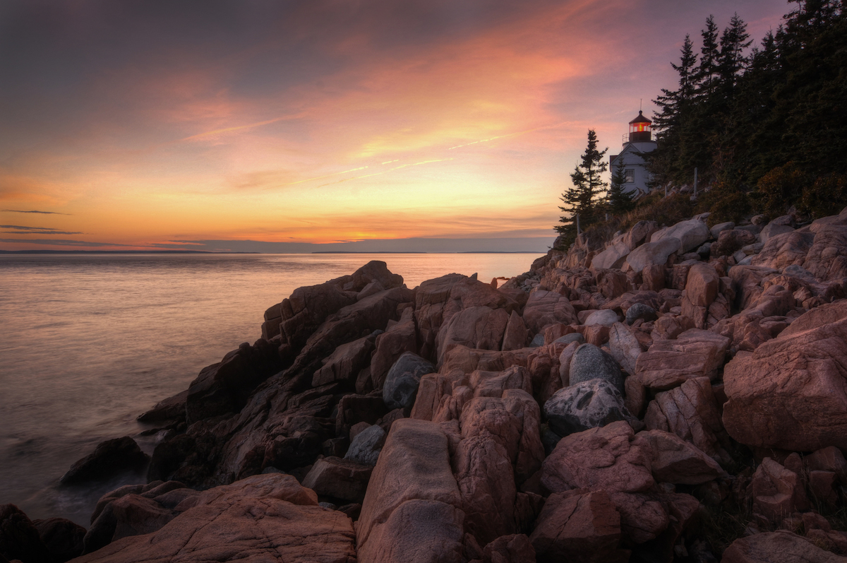
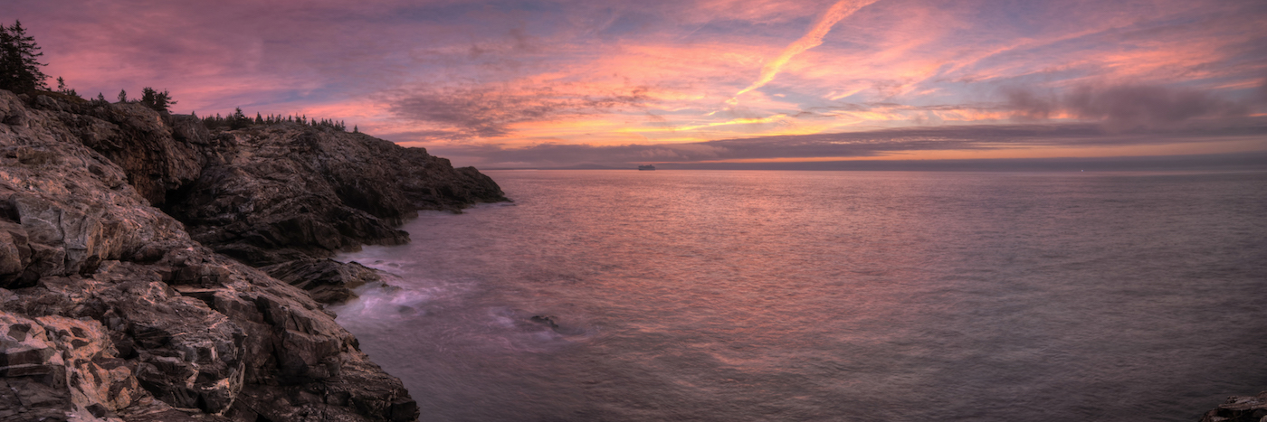
As you may have guessed from the content so far, the shot I was most interested in Acadia was the Bass Harbor Head Lighthouse at sunset. I planned, I scheduled, and I took my photos. Overall, I would say that this location lived up to the hype. I managed to catch a decent sunset along with some OK clouds. The experience wasn’t ideal though. As I mentioned above, I got to the lighthouse a couple hours before sunset. I moved around until I found my spot and then just hung out. As I waited, people/groups came and went. It wasn’t until about 30 minutes before sunset (the time when sane people arrive) that it started to get packed. One guy told me, after I’d been standing there for 2 hours, that I was “going to be in people’s way.” Most people, he said, take pictures from further back. The rocky shore near the lighthouse is pretty narrow and there are only so many rocks to perch on. If someone is ahead of you then, you have to include them in your photo. I sympathized with what the guy was saying but didn’t want to move. Luckily there were rocks on the shore large enough to hide me (and several other early arrivals) from the 20 or so people who had set up behind us. Unfortunately, this meant we were crammed into narrow spots and that, if we moved, we could end up pissing off all the people behind us. So I stood still taking essentially the same photo over and over, with slight adjustments to the settings. It worked out but it was less than ideal.
Other Resources
- Acadia National Park on NPS.gov – You can get information straight from the people who know best.
- My Acadia National Park Gallery on Flickr – A collection of my photos from this trip on Flickr.
- My Acadia Pinterest Board – My collection of other people’s photography from this park.
- My Other National Park Galleries on Flickr – A collection of all my National Park Galleries. I’m planning on building this collection as I visit new parks, so check back.
Useful Tools
- Fall Color – Foliage will vary depending on weather conditions, but I found this site helpful in making a best guess even months beforehand. Peak dates fall between October 13th and 22nd.
- Tide Charts – Given that much of the natural beauty of Acadia lies along the coast, it is good to stay aquanited with the tide. I knew very little about the tides before making this trip. I printed an abbreviated chart from this website and carried it with me.
- The Photographer’s Ephemeris – TPE allows you to drop a pin on a Google map and see not only the sunrise/sunset and moonrise/moonset times but also the direction the sun and moon will rise and set.
If you have any questions or comments about this article, let me know using my Contact page.
Pingback: Planning Photography Adventures – brandonkopp.com