
| My Experience | |
|---|---|
| Number of Visits | 1 |
| Length of Stay | 2.5 Days |
| My Favorite Spots | Cascade Canyon Moulton Barn Schwabacher’s Landing Jenny Lake Hedrick Pond Overlook |
| Expenditures | Hotel: Not Recorded Flight: Not Recorded Rental Car: Not Recorded Food: Not Recorded |
| Miles Hiked | ~20 |
| # of Photos Taken | Not Recorded |
The Trip Overall
From ages 8 to 11, I grew up in Idaho. For the other 30+ years of my life, I have lived in some of the flattest states in the U.S. Despite this, or maybe because of this, I have always been drawn to the mountains. That is why I was so excited to plan my trip to Grand Teton. This trip was part of a larger trip that also included Yellowstone and after 5 days on my own, I was glad to have my friend Chris join me for this portion of the trip. Chris is a great travel companion because he challenges me to do things I may not have done otherwise. This time that included a 12 mile, round-trip, hike up Cascade Canyon that turned out to be the highlight of the trip for me.
I planned for a solid 2 1/2 days in the park, but it wasn’t enough. Due to the wall of mountains, Grand Teton National Park is definitely made for sunrise and I needed more sunrises. The weather didn’t cooperate as I’d hoped and there are too many amazing things to include as a foreground in a photo. This is a trip I’ll be making again.
The Map
One of the great things about Grand Teton National Park is that many of the iconic photo locations are along the main roads; Highway 191, Teton Park Rd., and Moose Wilson Rd. If you only have a couple days to spend in the park, you don’t have to spend a lot of time hiking. That said, there are some fun hikes in the park as well.
[googlemaps https://www.google.com/maps/ms?msa=0&msid=215447723233123953430.0004d2577bdafea4a6905&hl=en&ie=UTF8&t=h&ll=43.697665,-110.606232&spn=0.496441,1.337585&z=10&output=embed&w=1200&h=600]
Click on the camera icons to see a photo, a location name, and coordinates for the closest parking area. I also show park entrances, visitor centers, the hotel(s) where I stayed, hiking trails, and airports.
Visitor Statistics
Visitorship in Grand Teton National Park follows much the same pattern as Yellowstone; peaking in July and then dropping off dramatically for the winter. Though I didn’t think much of it when planning my trip for September, snow on the mountains is important for iconic shots. When I first arrived, there was no snow. Luckily, a snowstorm blew through by the time I ventured back south. Though it can snow in any month, planning a trip for Late August or early September can be risky for this reason. Also, the end of September is often peak for Fall color.
This graph shows the average number of visitors each month. Hover over the line to see values for each month. NOTE: Even though the X-axis reads “2000,” these are monthly averages from the most recent 5-year period. The “2000” should be ignored.
The Climate
The data in this tool match pretty closely with what I experienced while visiting in mid-September. High temperatures were in the low to mid-60s and low temperatures were around freezing. One thing I hadn’t anticipated was morning fog. It was present like clockwork all three days I was there, but burned off at different times. Only one day did it exit before sunrise.
This graph shows average temperature and precipitation by month. Hover over the line to see values for each month. You can select different variables and parks in the panel on the left. NOTE: Even though the X-axis reads “2000,” these are monthly averages of NOAA weather data dating as far back as the early 1900’s. The “2000” should be ignored.
Logistics
| NPS Survey Findings(1) | |
|---|---|
| % Visiting for First Time | 60% |
| % Staying More than 24 Hours | 44% |
| Average Length of Stay | 1.7 Days |
| Top 5 Sites Visited | Jenny Lake (70%) Coulter Bay (48%) Moose (46%) Snake River (46%) Jackson Lake Lodge (42%) |
| Average Expenditures | ~$416 per person |
| (1) Visitor Survey Project Report Grand Teton National Park 2008 | |
Lodging
We stayed at the Cache Creek Motel in Jackson, WY. It is well positioned on the northern end of the town making for an easy drive north on Highway 80 to the park. It is also less than half a mile walk to the downtown area of Jackson if you want to walk down there for some drinks.
Food
When I flew into Jackson Hole Airport, I drove into Jackson and bought groceries. After spending several days in Yellowstone, I still had some left over and that is what I ate for lunch while in the Tetons. Both nights that we were there, Chris and I ate at the Town Square Tavern. It is a bar and grill with burgers and wings, which both of us were looking for so we went back. On one of the days, we ate at a sub shop called Full Steam Subs and on the last day, Chris left early so after I finished taking sunrise photos I stopped at The Bunnery to pick up coffee and some pastries. There was a huge line so I didn’t stay, but this place came highly recommended. All three of these restaurants were great and I would recommend them if they are the type of food you’re into.
My Experience
I have mixed feelings about my time in the Tetons. The weather in the mornings, when I most needed cooperative weather, was not ideal. The rest of the time was great though. I made it to most of the places I wanted and took my photos. They didn’t all turn out as well as I’d hoped, however. In preparing for this trip, I bought Jeff Clow’s Dirt Cheap Photo Guide to Grand Teton National Park. Jeff is an outstanding photographer and his photos served as much of my inspiration for visiting the park. To a certain extent, I followed the itineraries he lays out in the book. I recommend reading it if you really want to dig into your planning and start daydreaming about how great your trip is going to be.
Day 0
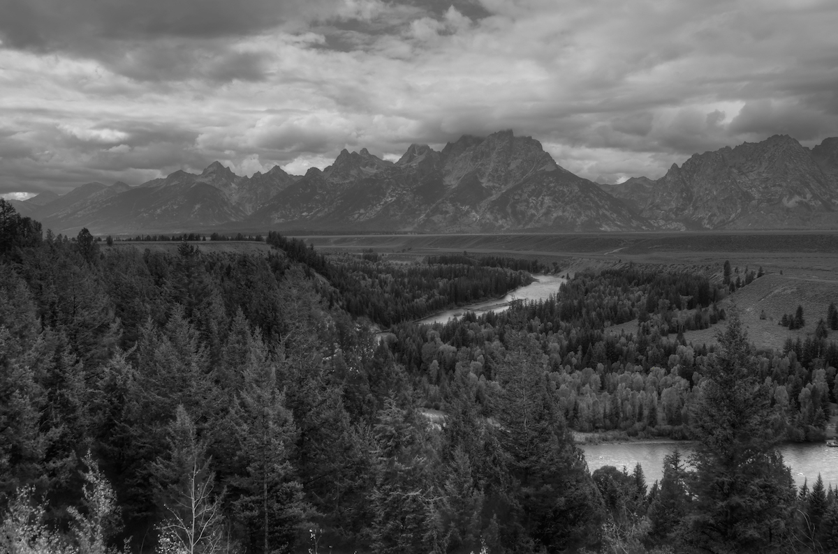
This trip was divided between Yellowstone and Grand Teton National Parks. I wanted to end the trip in the Tetons so I flew into and out of Jackson Hole Airport. On my first day, I rented a car, bought groceries in Jackson, then drove past the beautiful Teton mountains on my way north to Yellowstone. The scenery was too amazing and the clouds were too perfect to resist stopping at the Snake River Overlook. This is the view that Ansel Adams made famous. In both my framing and processing, I tried to replicate the shot he’d taken so many years ago. This was the only stop I made. Otherwise, I drove straight through to Old Faithful and spent the next 4 days in Yellowstone.
Day 1
On the morning it was finally time to head back to the Tetons, I woke up around 4 a.m. I made the 1 1/2 hour drive from the Old Faithful cabins to Oxbow Bend in complete darkness. I was meeting Chris there at sunrise and didn’t want to be late. On the drive down, I had gone through patches of rain and was nervous about the sunrise. It turns out I had reason to be. The rain had pretty much stopped by sunrise but it was too cloudy to see either the rising sun or Mount Moran. Once Chris arrived we left his car at the parking lot and drove my car into the park along Teton Park Rd. Our first stop was at the Chapel of the Sacred Heart, thinking that we could take some interior shots while we waited for the clouds to break. The door was unlocked, but despite our best efforts, we couldn’t find the switch to turn the lights on. So we left and headed south. On the recommendation from a guy I met in Yellowstone, we stopped at String Lake. It was still too cloudy to get decent shots, so we headed to Jenny Lake. We walked down to the shoreline and, by then, the clouds were starting to lift so we stuck around there for about 45 minutes, taking photos. Next, we stopped at the Chapel of the Transfiguration near the park’s south entrance. We took interior and exterior shots. There weren’t many people around, so it was nice to take our time and try some different angles. The photo on the right was one of the shots I had planned out and knew roughly what angle I wanted to take the photo and that I wanted to use a longer focal length to make the mountains appear closer in the background.
By this time, it was about 10 a.m. and the best of morning’s light had passed so we decided to take a mid-day break from photography. We drove back to retrieve Chris’ car at Oxbow Bend, stopping along the way at Signal Mountain. We then drove into Jackson, checked in at the Cache Creek Motel and ate lunch. After a nap and time to check out the morning’s photos, we drove west out of Jackson on the Teton Pass Highway and then north on the Moose Wilson Road. I’d heard that that was one of the better places to view wildlife. We stopped at several turnouts and got out and walked, but didn’t see much other than deer off in the distance. Traveling a bit further north, we started to run into bear jams; cars stopped along the road so people could see and photograph bears. We stopped too and tried to get decent shots, but I was sorely disappointed. The bears were often far away and obscured by trees. On top of that, they were small black bears…not as impressive as grizzlies I had seen. Occasionally, park rangers would come and tell people to move along in order to break up the bear jam. So we drove up and down Moose Wilson Road several times trying to see more bears or other wildlife. We saw 4 bears, but still no decent photos.
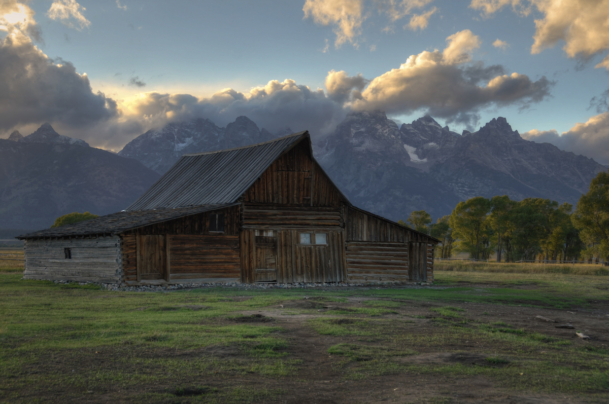
We wanted to spend sunset along Mormon Row, so that’s where we headed next. We stopped at the northern edge of the row first, where there is a homestead and the less popular of the two Moulton Barns. I liked this one more than it’s more famous cousin, because of the broken fencing it has along it’s east side. We took photos in this area for awhile and then drove about half a mile south to The Moulton Barn. Just as we arrived, about half a dozen cars pulled up, each packed with photographers; a photography class actually. They fanned out along he eastern boundary of the property, which is good photography etiquette for the Barn because that is where most people shoot from and you don’t end up in other people’s photos. We stayed there, trying out different compositions until the sun set behind the mountains and then went back to Jackson for dinner and sleep.
Day 2
My first sunrise in the Tetons had been rainy and cloudy. The second morning was not much better. Chris and I drove north on Highway 89 looking for the turnoff to Schwabacher’s Landing. It wasn’t hard to find. There were already several cars parked on the shoulders of the road. The dirt road down to the Landing was closed. We hiked the mile or so down to the Landing in the dark and looked for a spot to set up. Dense fog had settled in overnight, but we were hoping it would lift before sunrise. It did not. We hung out at Schwabacher’s Landing with about 10 other people until sunrise. At that point the fog was still so thick you could barely see the other side of the river, let alone the beautiful mountains that were supposed to be the main subject of the picture. The other photographers were convinced that if they waited another hour, they’d get the shots that they wanted. Chris and I were impatient and less optimistic so we headed toward Jenny Lake.
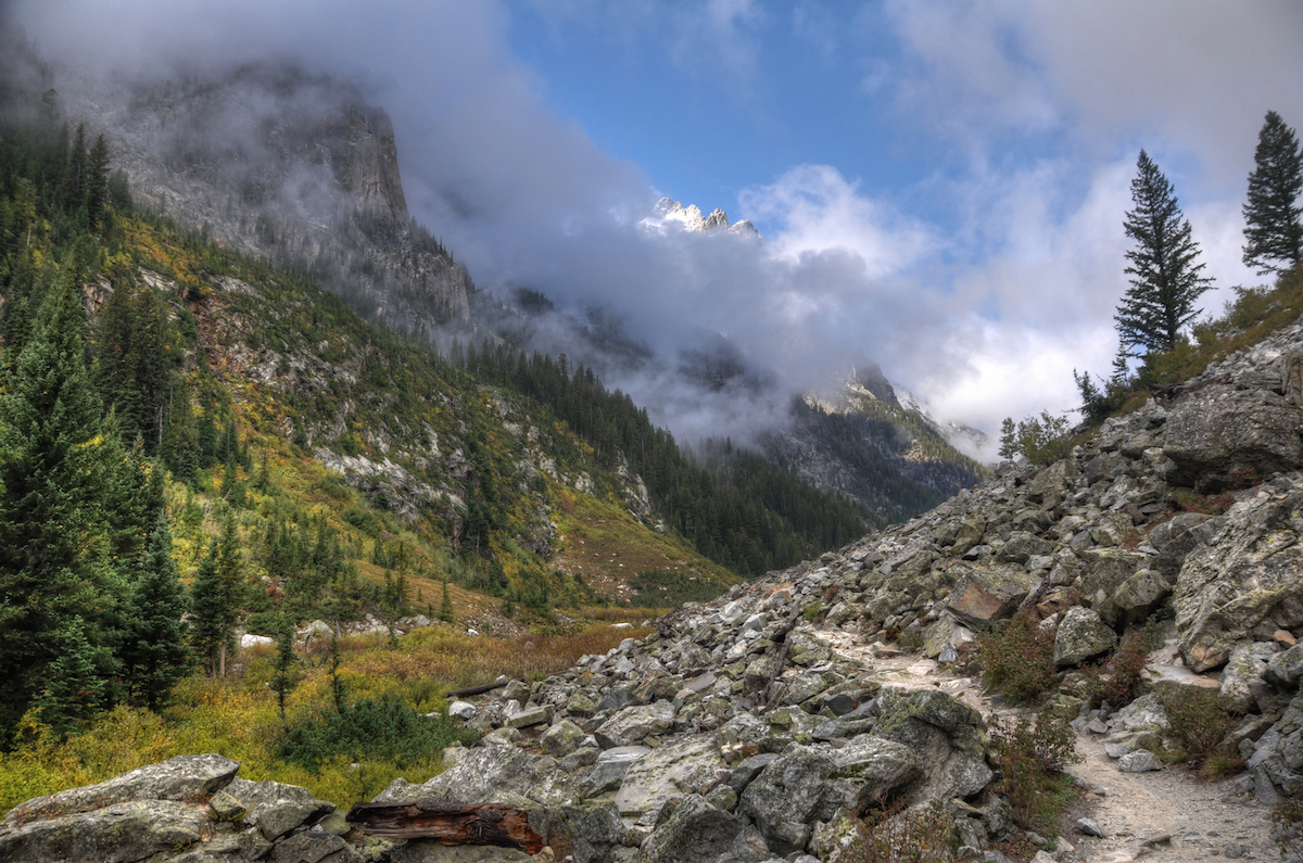
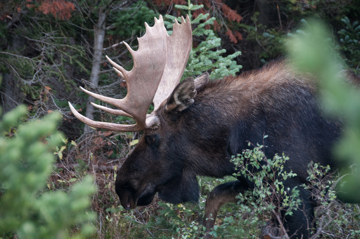
I had mapped out a hike that goes about 1/3 of the way around the lake from the Jenny Lake Visitor’s Center to Inspiration Point. Early on in the hike, we met a local (or at least a frequent visitor) who said that we absolutely had to keep going past Inspiration Point into Cascade Canyon if we wanted to see wildlife. He guaranteed that we would see a moose, which we hadn’t seen yet. The morning was still really foggy, so there was no harm in hiking a bit farther in the hope of seeing a moose. We made the hike to Hidden Falls and Inspiration Point. My sea level acclimated lungs were burning by that point. Hidden Falls was decent, but not great. Inspiration Point wasn’t very inspirational at that point due to the fog (which was lightening up but still present). Luckily for my lungs, the path into Cascade Canyon mostly levels out after Inspiration Point. We walked the path up to where it splits to go to Lake Solitude or Hurricane Pass. We’d hike for 6.5 miles at that point without seeing ANY wildlife and I felt a little cheated. We started to head back and about a mile into the journey, we ran into a group of people photographing a male and female moose. The earlier hiker was right. I was excited to see a male moose. I may still have been disappointed if all we’d seen is the female. The moose stuck around in this clearing for about 30 minutes while the male appeared to be marking some territory. All of the sudden, people gasped and were pointing at the other side of the clearing where a black bear went running across the path. Attention shifted to the bear for the short time it remained close. With the goal of the hike met, we quickly hiked back down, stopping again at Inspiration Point, which was much more breathtaking now in the clear weather. All-in-all, that 13 mile hike took about 8 hours.
[youtube=https://youtu.be/mncwTyNZF08]
After getting something to eat and relaxing a bit, we went out to drive Gros Ventre (pronounced, Grow Vont) Road looking for wildlife. We’d heard from several people that a female moose and her calf had been seen there repeatedly. We did see the moose along with dozens of people with cameras ranging from cell phones to 800mm lenses. It was an interesting site. Once we’d had our fill of moose we headed to the wooden fences across from the Triangle X Ranch. We were at a loss for what would make a good sunset spot, especially now that the sky was clear. It was a mediocre sunset and the photos that came out of it weren’t that great. So we wrapped things up and headed back into Jackson.
Day 3
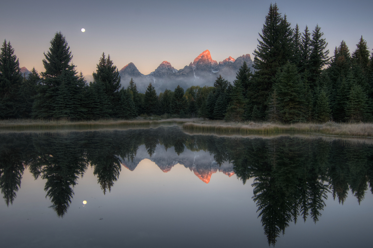
Chris had to leave at 3 a.m. on the last morning to make the 8 hour drive back to Denver to work (crazy), but I still had until 11 a.m. to get to the Jackson Airport. I decided to try my luck with Schwabacher’s Landing again. That was a shot that I knew, if I could get it, would pay off. Again, I parked on the highway and made the hike down. This time when I arrived, there were 15-20 people there from a photography class. I found a spot to set up and waited. The fog was dense again, but with the help of the full moon you could slowly see it lifting. It was about 30 minutes before sunrise that I got my first glimpse of the mountains. Then it started clearing rapidly. It was about 5 minutes prior to sunrise when the first light hit the top of the mountains; alpenglow. I stayed until about 20 minutes after sunrise but wanted to get some other photos, so I made the mile hike back out.
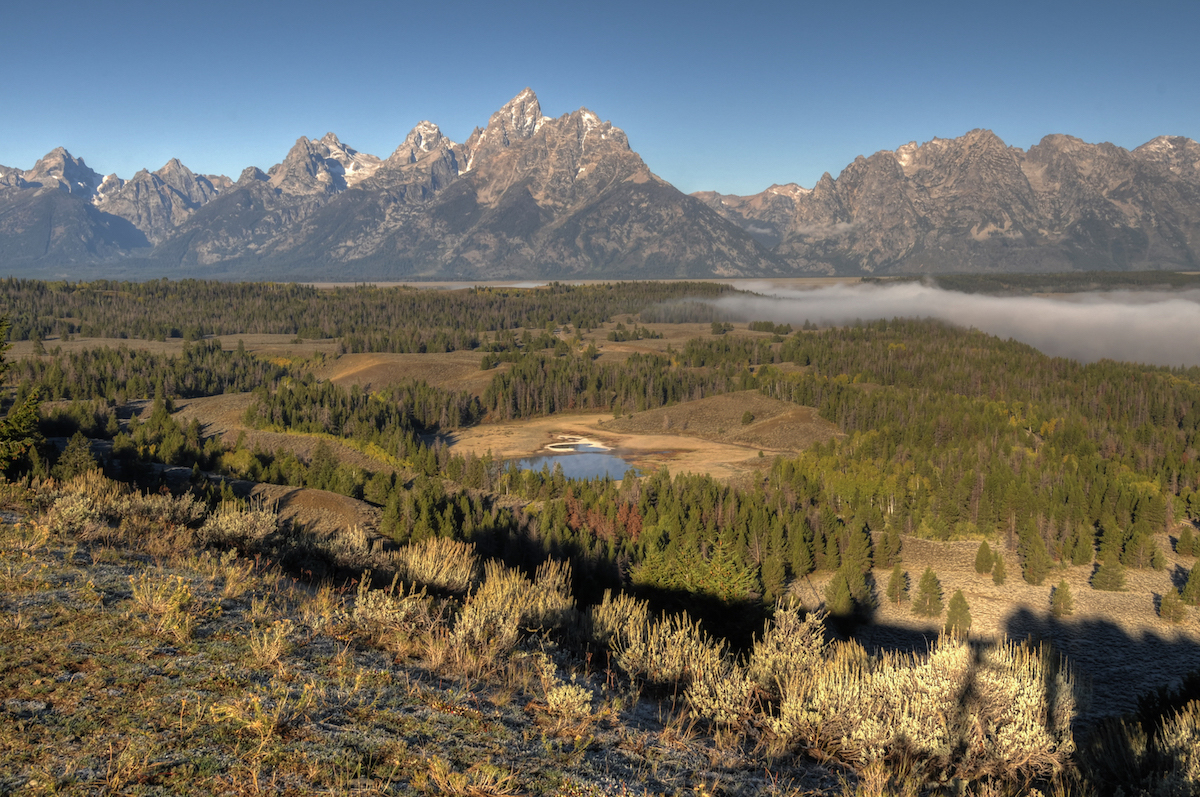
I drove toward the Hedrick Pond Overlook. In Jeff Clow’s book, he described how rough the road could get. He wasn’t kidding. My tiny rental got knocked around quite a bit on the main dirt road. When I turned off onto the last little side road, I saw a series of small ponds in the road (at least the ruts looked like that). I forded one of the ponds but quickly got scared that I would be stuck out there so backed my way out to the main road. Sagebrush grows right up to the road, so there wasn’t much of a shoulder. Luckily, there was an area where it looks like someone had trampled down the brush so I parked there, my car still about 1/4 of the way into the road. I walked the last 1/4 mile to the overlook. My pants were soggy and covered with mud by the time I got there. I’ll tell the rest of the story The One Shot section below.
By the time I left the overlook, I was pretty burnt out on photography. I was ready to relax in the airport, drink coffee, and start looking through the photos I had taken. I couldn’t resist one last stop at the Snake River Overlook though. But that was it.
[youtube=https://youtu.be/Fq73zaVTi74]
What I Would Do Differently
I make plans well in advance of my trips so that I can daydream and think out what I want to do, what equipment I want to bring, etc. For Grand Teton National Park, most of that daydreaming centered around sunrise. Unfortunately, you can’t account for the weather and I ended up having to improvise when my plans were knocked off track. There isn’t much that I can do differently about the weather. I just need to go again and hope for something better. I would like to go back in May, when the crowds haven’t quite picked up and there’s still quite a bit of snow on the mountains. Perhaps a short winter trip too, though I would rent a vehicle with 4-wheel drive.
The One Shot
I read about the Hedrick Pond Overlook in Jeff Clow’s photo guide to the Tetons. In searching through Flickr photos, I saw that Jeff was right in describing this as a relatively unique shot of the valley and mountains. I was excited to get my own version of the shot. Jeff suggests this spot as a place you would go later in the morning, but I was so excited to get the shot on my last day in the park, that I went there shortly after sunrise. I realized quickly why he’d suggested going later. The hill that you’re standing on casts a long shadow that isn’t very appealing. With no clouds the sky wasn’t much better. This spot had a lot more potential than was available the day that I went. If/when I make it back to the Tetons, I’ll definitely visit this spot again.
Other Resources
- Grand Teton National Park on NPS.gov – You can get information straight from the people who know best.
- My Grand Teton National Park Gallery on Flickr – A collection of my photos from this trip on Flickr.
- My Yellowstone/Grand Tetons Pinterest Board – My collection of other people’s photography from this park.
- My Other National Park Galleries on Flickr – A collection of all my National Park Galleries. I’m planning on building this collection as I visit new parks, so check back.
Useful Tools
- The Photographer’s Ephemeris – TPE allows you to drop a pin on a Google map and see not only the sunrise/sunset and moonrise/moonset times but also the direction the sun and moon will rise and set.
If you have any questions or comments about this article, let me know using my Contact page.
Pingback: Yellowstone National Park – brandonkopp.com
Pingback: Yellowstone National Park | brandonkopp.com